Radar GO-X: HUD, GPS, Maps
- 4.1
- Rating
- 10.00M
- Installs
- Free
- Price
 Analysis by App-foxy
I find Radar GO-X: HUD, GPS, Maps most useful as a driving companion rather than as a complete replacement for a dedicated navigation system. It brings several road-focused tools into one Android app: radar and speed-camera alerts, a speedometer, a location tracker, a heads-up display, and flight tracking. That combination makes it interesting for people who want quick awareness while driving, walking, or monitoring a journey, but it also means the experience depends heavily on how clearly you can read the screen and how safely you can interact with it.
After spending time with it, my main impression is that the app is trying to solve a practical problem: drivers often switch between separate tools for speed, location, road alerts, and travel information. Having those functions together is convenient. The trade-off is that a multi-purpose dashboard can feel less focused than a specialist navigation app. I would recommend it to someone who wants a compact set of vehicle and location tools, especially if a simple visual display matters. I would be more cautious for anyone who needs highly detailed route guidance or must operate a phone with minimal visual interaction.
How readable navigation feels in everyday use
I focus here on how easy it is to read navigation information in brief, ordinary checks, including how glare, placement, and visual clutter can change that experience. That matters because a screen that looks clear while parked may feel quite different once the car is moving.
You May Also Like

 AccuWeather: Weather Radar
AccuWeather Review: A Quick, Clear Forecast for Everyday Decisions
For everyday plans, the best forecast is the one you can understand quickly. AccuWeather makes rain timing, radar, and local conditions easy to act on, with a few trade-offs.

 Hill Climb Racing
Why Hill Climb Racing Still Turns Crashes Into One More Run
A tiny car, a bumpy hill and one more upgrade: Hill Climb Racing keeps resurfacing because its simple chaos makes every near-miss feel personal.

 AliExpress - Shopping App
AliExpress Makes Global Shopping Feel Personal, but Shoppers Bear the Risk
AliExpress turns a global marketplace into a pocket-sized discovery engine. Its reach is useful, its shopping loop compelling, and its trade-offs easy to miss.

 Lords Mobile: Kingdom Wars
Lords Mobile Is a Kingdom-Building Routine, Not a Quick Match
A case-by-case verdict on the building, battles, device demands, and social commitments that make Lords Mobile rewarding for some players and exhausting for others.

 PDF Scanner app - TapScanner
TapScanner Makes Paperwork Easier to Capture, Check, and Share
TapScanner makes scanning with a phone feel less like a rescue operation and more like a dependable step in getting work done. Its capture tools are useful, though not flawless.

 Block Blast!
 Shows How Much a Puzzle Game Can Leave Out
A quiet grid game shows why puzzle players increasingly value instant clarity, repeatable skill and low-pressure play—and where the genre still needs to catch up.
More From Our News Desk
View All News


A dashboard built around quick visual checks
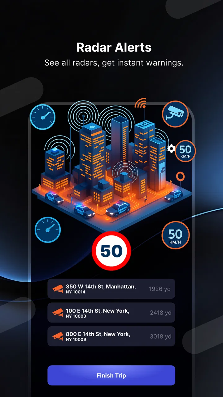
The strongest part of Radar GO-X is the idea of checking essential information at a glance. A speedometer is easier to understand while moving than a crowded collection of menus, and a HUD can place useful information in the driver’s field of view when the phone is positioned appropriately. I see the value here during a familiar commute: instead of opening several apps, I can use one screen to keep an eye on speed and receive road-related awareness.
That said, a heads-up display is only helpful when the projected or reflected view remains easy to interpret. Bright daylight, glare, phone placement, and the condition of the windscreen can all affect readability. I would test the layout while parked before relying on it in traffic. If the figures or warnings require squinting, repeated glances, or leaning toward the phone, the feature stops being an aid and becomes a distraction.
The app’s usefulness also changes with the user’s visual preferences. Some people will appreciate large, direct information with little decoration. Others may want more control over contrast, text size, alert presentation, or screen density. I would not assume that a display comfortable for one driver will suit another. The practical approach is to set up the phone in a stationary car, adjust the viewing angle, and decide whether the information can be understood in a brief glance.
Maps and location information without overcomplicating the trip
Maps and location tracking give the app a wider role than a basic speedometer. I can imagine using the location view before leaving to understand where I am, then switching attention back to the road once the journey begins. The tracker may also be useful on a walk, during a sightseeing day, or when trying to keep a general record of movement rather than follow a complex route.
My advice is to treat the map as a planning and orientation aid, not as permission to study the screen while moving. If I need turn-by-turn detail, lane guidance, destination search, or a carefully planned multi-stop journey, a dedicated navigation application is likely to feel more complete. Radar GO-X makes more sense when the priority is combining location awareness with vehicle information.
For people who find small map controls difficult, the workflow matters. I would search, choose a destination, and inspect the route before pulling away. I would also avoid trying to change map views or investigate an alert while driving. This is not just a safety habit; it makes the app more accessible because it reduces the need for precise taps under pressure.
Alerts need to be understood, not merely noticed
Radar and speed-camera information can be useful because it encourages a driver to pay attention to changing road conditions and speed limits. However, an alert is not a substitute for observing signs, road markings, or local rules. I would treat every warning as a prompt to become more attentive, not as a guarantee that every camera or restriction has been identified.
This distinction is especially important for users who may not hear an alert clearly or who find sudden sounds uncomfortable. A visual warning can be easier for some drivers, while others may need an audible cue because looking at the display is difficult. The app’s practical accessibility therefore depends on how its alerts are presented and whether the user can notice them without taking attention away from the road. Anyone who relies on one particular sensory channel should test the app in a safe, stationary setting first.
Motor, sensory, and situational access
I look at how people with different motor and sensory needs can prepare the app, notice information, and avoid unnecessary interaction during a trip. The next section turns to the practical limits that remain even when the setup is carefully adapted.
Reducing taps can make a bigger difference than adding features
Driving already demands constant physical and mental attention, so the best workflow is the one that requires the fewest interactions after departure. I would prepare the app before starting the engine: choose the needed mode, position the phone, check the display, and leave the controls alone. This is a simple habit, but it makes the combined feature set much more manageable for people with limited hand movement, tremors, joint pain, or difficulty making accurate taps.
For a user with motor limitations, the biggest question is not whether the app contains several tools; it is whether those tools can be reached without repeated small gestures. A large, stable display is easier to use than a screen that demands frequent menu changes. A phone mount also matters because holding the device while driving is unsafe and because an unstable phone makes touch interaction harder. I would pair the app with the user’s normal safe phone-control method rather than trying to operate it one-handed on the road.
There is also a useful distinction between setup access and driving access. Someone may be perfectly comfortable configuring the app at home but struggle to make changes in a moving vehicle. I would encourage a support person to help with the initial arrangement if needed, then keep the active driving view as simple as possible. This approach benefits almost everyone, including drivers who do not consider themselves to have an accessibility need.
Different sensory needs call for different ways to confirm information
The app covers visual information particularly well in concept: maps, speed, location, and HUD output all lend themselves to visual checking. That can suit drivers who prefer seeing information rather than hearing spoken instructions. At the same time, a visually focused dashboard may not be enough for someone with low vision. If reading the display requires extended attention, I would choose a different navigation setup or use Radar GO-X only when parked or as a secondary tool.
For users with hearing loss, visual warnings may be more dependable than sound, but they still need to be noticeable in changing light. For users who are sensitive to flashing, sudden alerts, or busy screens, a restrained configuration is preferable. I would avoid assuming that more warnings automatically create more safety. An alert that is easy to miss, confusing, or overwhelming can be less helpful than a smaller number of clear prompts.
People with cognitive disabilities may appreciate the app’s single-purpose modes, particularly when they can select one task at a time. The risk is that the overall collection of functions can create decision fatigue. Before a trip, I would decide whether the priority is speed monitoring, radar awareness, location, or flight tracking. Keeping one clear purpose in mind makes the app easier to understand than switching between every available tool.
Useful beyond the driver’s seat
Radar GO-X is not limited to one driving scenario. The location tracker could help someone keep a general sense of where they have travelled, while the flight tracker may be useful when meeting a passenger or checking the progress of a journey. These situations can be more accessible than active driving because the user has time to look at the screen, enlarge their attention, and ask for assistance without creating a road hazard.
Here is a realistic example: I might be driving to collect a relative from an airport. Before leaving, I could use the flight-tracking function to understand whether the arrival is progressing, then use the speedometer and road-awareness tools during the trip. Once parked, I could check the map and location information to find the correct meeting area. The value is not that one app magically handles the whole journey; it is that the functions sit close together and can be used at different stages.
For a passenger, the app can also be a practical travel screen. A passenger could monitor location or flight progress while the driver concentrates on the road. This division of roles is important for inclusive use: the person who needs the information does not always need to be the person controlling the phone.
What the app offers compared with usual alternatives
Compared with a standalone speedometer app, Radar GO-X is broader because it combines speed with radar awareness, maps, tracking, HUD presentation, and flight information. Compared with a full navigation service, it appears more like a collection of focused driving and travel utilities than a deeply specialized route planner. Compared with a separate flight tracker, its advantage is convenience rather than depth.
I would choose it when I want one place for quick vehicle information and occasional location or flight checks. I would choose a dedicated navigation app when route planning is the central task, especially for unfamiliar roads or complicated journeys. I would choose a specialist accessibility-oriented setup when I need guaranteed compatibility with a particular screen reader, switch device, voice workflow, or high-contrast arrangement. Radar GO-X may fit into that setup, but I would not make it the sole tool without testing it first.
Remaining barriers before making it part of a routine
I consider the points that deserve a real-world check before relying on the app, from phone placement and interruptions to the demands of switching between tools. These barriers help clarify when a simpler or more specialized option may be the better fit.
Road safety limits how much interaction is realistic
The most important limitation is shared by every phone-based driving tool: the driver cannot safely explore it while moving. A person with reduced dexterity, slower processing, or limited vision may need more time to complete a task, yet the road does not provide that extra time. The solution is preparation, not faster tapping. Set the app up before departure, mount the device securely, and pull over whenever a change is genuinely necessary.
I also would not rely on the app as the only source of speed or road information. A phone can lose visibility because of glare, a poor mounting position, or an unexpected interruption. The vehicle’s own instruments and the road environment remain important. Radar warnings should never encourage speeding between alerts, and a map should never override signs or instructions from authorities.
Free access is appealing, but optional spending deserves attention
The app is free to download and has an Everyone age rating, which makes it approachable for a wide range of users. Appwest Limited is the developer, and the current version is 5.37.0. Optional in-app purchases range from around five dollars to around thirty dollars per item, so I would check what is included before paying for anything.
That pricing structure matters for families, older users, and anyone who wants to keep a driving setup predictable. I would begin with the free experience and identify the exact function that is missing before considering an upgrade. If the free tools already cover speed and basic awareness, paying may not improve the parts of the experience that affect readability or physical access. In other words, a purchase cannot solve an unsuitable screen layout or an unsafe mounting position.
Performance expectations and device compatibility
Radar GO-X supports Android 6.0 and later, which gives it a broad potential device range. Still, an older phone may offer a less comfortable experience than a newer one, especially if the display is dim, small, or difficult to position. I would judge compatibility by the actual phone, not only by the operating-system requirement. A technically supported device can still be a poor fit for someone who needs large, crisp information.
The app has passed the scale test for a popular utility, with over ten million installs and an average rating of 4.1 from around fifty-nine thousand ratings. Those figures suggest that many people find the general concept useful, but they do not tell me whether the interface suits a particular visual, motor, or sensory need. I would use the rating as a reason to investigate, not as a guarantee of personal accessibility.
Another practical barrier is context switching. Moving from a radar view to a map, then to a flight tracker, may be convenient before a journey but distracting during one. I recommend assigning each mode to a specific moment: prepare the map before leaving, use the driving display on the road, and check flight details only while parked or as a passenger. This simple separation is one of the most effective ways to make a multi-tool app feel less demanding.
Who should skip it
I would skip Radar GO-X if I needed a navigation system built around advanced route planning, highly detailed spoken guidance, or a carefully tested accessibility workflow. I would also avoid making it central to my driving routine if the HUD or map cannot be read comfortably in my vehicle. A separate speed display or a manufacturer-integrated system may be better when reliability, physical controls, and minimal phone interaction are the priorities.
It may also be the wrong choice for someone who wants one simple function and dislikes extra options. The combination of radar, speed, maps, tracking, HUD, and flight information is useful only when those functions match the person’s habits. If I only need directions, a standard navigation app will probably feel more direct. If I only need flight status, a dedicated flight service may provide a clearer experience.
My inclusive verdict after using the whole concept
Radar GO-X: HUD, GPS, Maps has a practical strength: it brings several forms of travel awareness into one free Android app. I like the way a driver can think in terms of quick speed and road checks while a passenger or parked user can turn to maps, tracking, or flight information. Its HUD approach may also help people who prefer a glanceable display instead of repeatedly looking down at a conventional phone screen.
Its accessibility is situational rather than universal. The app can support different abilities when the user prepares it carefully, chooses a readable display, separates driving tasks from parked tasks, and avoids relying on a single kind of alert. It is less convincing for anyone who needs extensive spoken guidance, guaranteed assistive-technology support, or a route-planning tool with a very narrow focus.
With its Everyone rating, free entry point, broad Android compatibility, and established user base, I think it is worth trying for drivers who want a compact dashboard of road and travel tools. I would start in a parked car, test the display in daylight and darkness, confirm that the alerts are noticeable without being overwhelming, and decide whether the phone can remain untouched once the journey starts. If those checks go well, the app can be a useful companion. If they do not, choosing a simpler or more specialized alternative is the safer and more inclusive decision.
FAQs for Radar GO-X: HUD, GPS, Maps
01What features does Radar GO-X offer?
Radar GO-X provides a comprehensive suite of features including a head-up display (HUD) for safer navigation, real-time GPS tracking, and detailed maps with traffic updates. It also offers speed limit alerts and customizable route options, making it an ideal choice for both daily commutes and long trips.
02Is Radar GO-X compatible with both iOS and Android devices?
Yes, Radar GO-X is designed to work seamlessly on both iOS and Android platforms. It ensures a consistent user experience across different devices, allowing you to enjoy its features whether you are using an iPhone or an Android smartphone.
03How accurate is the GPS tracking in Radar GO-X?
Radar GO-X uses advanced GPS technology to provide highly accurate location tracking. It updates your location in real-time and offers precise directions. The app is continuously optimized to ensure reliability, even in areas with poor signal coverage.
04Does Radar GO-X consume a lot of battery power?
While Radar GO-X is feature-rich, it is also optimized for energy efficiency. The app has been designed to minimize battery drain, but as with any GPS-based application, prolonged use can impact battery life. It's recommended to use a car charger for extended trips.
05Are there any subscription fees for using Radar GO-X?
Radar GO-X offers both a free version with basic features and a premium subscription that unlocks additional functionalities, such as enhanced map details and ad-free experience. Users can choose the plan that best fits their needs, with the option to upgrade at any time.
Pros
- User-friendly interface for easy navigation.
- Real-time traffic updates enhance planning.
- Offline maps save data and battery.
- Customizable HUD for a personalized view.
- Voice-guided navigation for hands-free use.
Cons
- Limited features in free version.
- Occasional GPS signal issues reported.
- High battery consumption during use.
- Ads can be intrusive in free version.
- Compatibility issues on older devices.

Radar GO-X: HUD, GPS, Maps
Gallery